

Features vGIS AR
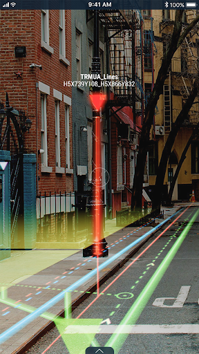
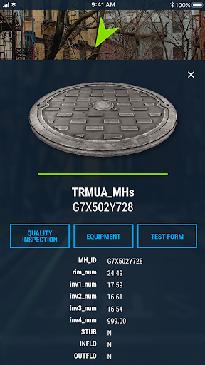
vGIS AR transforms traditional BIM and CAD designs and GIS data into real-time augmented reality displays that are overlaid on your view of a physical job site with centimeter-level accuracy.
The system combines object holograms with object-specific data to provide a hands-free method for field technicians to understand the infrastructure they need to service while on site, quickly and safely.Key features:• Exceptional Accuracy• Consistent Visualizations: 3D overlays stay “world-locked” by remaining in sync with the physical world• Multi-Device Support• No Additional Equipment: vGIS Utilities does not require any additional equipment• Workflow Integration: vGIS Utilities integrates with your existing back-office systems• Advanced Collaboration: Integrated holograms, video, and audio that connect the office with field teams• Format Support: Esri Feature Services, Esri Map Services, Esri Scene Services, Esri Building Services, Bentley iTwin, WFS, WMS, WMTS, GeoJSON, KML• GNSS Integration: Leica GG04 plus, EOS Arrow Series, SXBlue, TopCon and Trimble R series/Catalyst• Multi-View Support: First-person on-site experience and birds-eye “zoom out” site overviews
Music Features
Enjoy high-quality music streaming and playback features.
Social Features
Connect and share with friends and the community.
Gaming Features
Enjoy immersive gaming experience with various game modes.
See the vGIS AR in Action
Get the App Today
Available for Android 8.0 and above